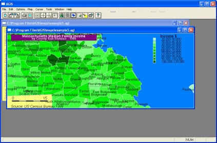
AGIS for Windows is a mapping and simple GIS shareware package. Maps and data can be provided by the user in the form of text files either created by other programs, or typed using a text editor. All control files used by AGIS are ASCII text, so it is easier to create such files using other systems.
The program has sufficient control dialogs built in to create and edit all control information without requiring the user to understand the structure of these files. High quality map images can be copied to the clipboard and pasted into popular packages such as Microsoft Word, or save directly to your hard disk as jpeg or bmp files.
A multi-document interface allows the concurrent display of a number of individual maps, each composed of a number of map and data layers. The latitude and longitude of the cursor is displayed at all times when over a displayed map, and cursor types are selected to allow zooming and measuring.
Output can be pre-viewed, and printed on any device supported by Windows. A system of "templates" are used to control display attributes of maps and data which should greatly simplify the production of maps which have many elements in common. A number of map projections are supported, allowing appropriate display of any part of the world, including the poles.
A built in scripting language allows you to create map animations and to link AGIS to other applications such as database queries. Scripting, combined with the ability to save map views in a number of raster formats also allows you to use AGIS to provide low cost vector-based map serving to your own web pages. To use the map serving capability, you web server needs to be running on Windows 95, 98, ME, NT, 2000 or XP.

Visualizes your tracks on Google Maps showing coordinates like latitude.


Comments